Project Update: Woolamai–Nyora Rail Trail Feasibility Study Now Complete
Bass Coast Shire Council, in partnership with South Gippsland Shire Council, has now completed the Feasibility Study for the proposed extension of the Woolamai–Nyora Rail Trail. The study was funded through the Victorian Government’s Investment Fast Track Fund and delivered by Michael Smith and Associates Landscape Architecture and Urban Design.
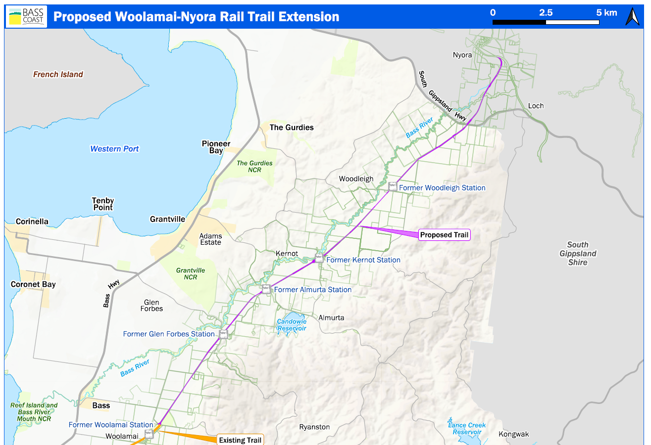
This 25-kilometre section forms a potential missing link in the concept for the broader 1,100-kilometre Gippsland Odyssey Trail—intended to connect communities and support regional tourism and active transport.
The Feasibility Study is a high-level investigation into the considerations and infrastructure that would be involved in developing a trail in this location. It examines a wide range of issues including fencing, drainage, biosecurity, trail profile and infrastructure, planning requirements, construction costs, and how to minimise impacts on adjacent farmland and vegetation. It also explores potential community and economic benefits.
At this stage, there is no budget allocated to progress the project to detailed design or construction. The study was undertaken to better understand the feasibility of a trail in this location and to inform any future decisions, should funding become available.
Council sincerely thanks all landholders, community members and stakeholders who contributed to the study. Your feedback has played an important role in shaping the final report.
The final Feasibility Study, Community Engagement Report, FAQs and supporting documents are now available to view [here / in the document library].
If you have any questions or would like to discuss the project in more detail, please don’t hesitate to contact us.
Proposed Woolamai-Nyora Extension
Frequently Asked Questions
Council is undertaking this feasibility work given that this project is a high priority project in our Tracks and Trails Strategy.
The purpose of the Study is to identify all requirements that would need to be met to enable this project to proceed to detailed design and construction. The development of the Study will include extensive engagement with affected landowners, as well as identifying any permits, approvals and structural requirements that would be needed to construct this trail.
Significant consideration has been given in the planning for this project to community and stakeholder engagement with a key focus on engaging with adjacent landowners to understand the leases and licenses over the proposed trail alignment and the impacts of trail development on landowners.
No. This project is a feasibility study, which will help to inform future investment in design and construction of the trail.
This feasibility study is not the detailed design or construction of the trail. Should the trail be considered feasible, further funding would be sought for the design and construction of the trail. This would likely occur in stages.
The project is funded through the State Government Investment Fast Track Fund, with a contribution from both Bass Coast and South Gippsland Shire Councils.
The completed feasibility study would allow the project to be considered to progress to detailed design and construction. This would be dependent on obtaining further funding and would likely be completed in stages over a number of years, given the size and complexity of this project.
Community benefits from growing Bass Coast’s Tracks and Trails network include:
- Connecting to townships and the wider region
- Providing infrastructure for health and wellbeing, and a connection to nature
- Creating tourism opportunities
This 25 kilometre section of trail is a missing link in the 1,100 kilometre Gippsland Odyssey Trail. Gippsland Odyssey will be one of the longest trails in Australia, extending all the way through Gippsland. providing new active recreation and commuter links for the community and transforming key tourism infrastructure.
Bass Coast Shire Council have completed an economic impact assessment for this project. The Woolamai to Nyora section of the Gippsland Odyssey Trail is expected to inject $875,000 in direct economic benefit to the region throughout the planning phase of the project and a further $36.12 million in direct economic benefit throughout the construction phase.
At this stage there is no financial commitment to proceed to construction. The feasibility study is a high-level investigation into the infrastructure and planning requirements, the potential risks, costs and benefits to the community if it was constructed in the future.
Over 96% of 423 survey respondents indicated they would use this trail if constructed. Rail trails across Victoria have gained in popularity and are used by locals and tourists alike for walking, running, hiking, cycling and horse riding. Links to railway history and nature are key attractions along with safe off-road connections and gentle grades. The emergence and growing popularity of e-bikes has introduced a new demographic of trail users. E-bikes allow for greater distances to be covered unlocking rural areas.
This trail would connect into the Great Southern Rail Trail between Loch and Nyora. Trail counters within a few hundred metres of this point, indicate on average around 70 trail users a day. Given the length of this trail, the popularity of new trails and the increasing distances covered on E-bikes, the number of users could grow well beyond this amount.
Council would most likely become the Committee of Management and maintain the rail trail as it does for the Wonthaggi to Woolamai section and other trails across the shire.
Yes, regulatory, warning, wayfinding and interpretive signage would be included in the detailed design.
The crown reserve varies between 22 metres and over 100 metres in width. Only 3 metres width would be required for the trail. Under the principals of avoid, minimise and offset, the trail could potentially weave in between existing vegetation as required. A detailed site survey, ecological assessment and arborist report would be part of the detailed design process. Significant planting would also be included into any design.
A key recommendation is to have regular trail heads that include shelter, seating, shade trees, a gravelled 5-7 car space car park, a bike repair station, a drinking fountain, a litter bin, way finding/distance signage and toilets. Some of these facilities exist at Glen Forbes, Kernot and Woodleigh and would be upgraded as part of the project.
There would be a significant boost to the local economy and creation of jobs during the construction phase. It would also be an attraction for tourists, forming part of the Gippsland Odyssey Trail which would increase direct and indirect expenditure. These benefits have been seen in other rail trails within the region.
Preliminary estimates which include significant contingency amounts for the project have the design and construction costs at $36million. Based on recent trail projects completed in the shire there is potential that this figure could be significantly reduced through the detailed design and tender process.
The feasibility study has identified four stages to the project and attracting funding for one stage a time would be far more viable than trying to attract a lump sum. Rail trail projects can attract state and federal government funding through several programs across tourism, active transport, recreation and community strengthening.


